Adventure with a Purpose: Quest to find top 5 free hiking/walking trails in Jozi 1/5 Klipriviersberg Nature Reserve
Adventure with a Purpose: Quest to find top 5 free hiking/walking trails in Jozi
KLIPRIVIERSBERG NATURE RESERVE:


Klipriversberg Nature Reserve is a short 10km from the center of Johannesburg close the the southern suburb of Mondeor and consists of hectares of open veld and koppies. It is only 5km from Soweto and can be easily assessed from Sandton and both the West and East Rand.


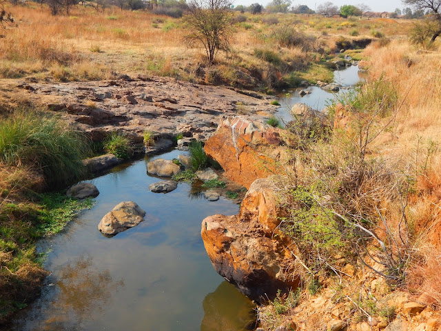
 The Bloubos Spruit ("blue bush stream") can be seen along most of the trails. This stream is one of the sources of the Vaal River. The Vaal river in turn is a source of the mighty Orange river.


 Mid-week walks

Specialist walks

Bird Walks


Enviro Club


Below is a great map of all the trails with the historical and archaeological sites clearly marked.

Region F, Zone 1
Address: Peggy Vera Road, Kibler Park
Telephone: 011 943 1312/2691
Reserve falls under JHB City Parks and Zoo: 011 712 6600

KLIPRIVIERSBERG NATURE RESERVE:
I love hiking and when its free even better. I have a family of five and finding a place that is affordable for a large family can be daunting especially when you want to awaken that adventurous spirit in your children. I live in Johannesburg South Africa and have started to search for my 5 top favorite free hiking spots in and around Jozi.


This one is a real gem and I have been wanting to tackle this one for some time but have never got around to it. It seemed a little too easy and close to Johannesburg and when I hike I like to get away into the mountains a bit.

Klipriversberg Nature Reserve is a short 10km from the center of Johannesburg close the the southern suburb of Mondeor and consists of hectares of open veld and koppies. It is only 5km from Soweto and can be easily assessed from Sandton and both the West and East Rand.
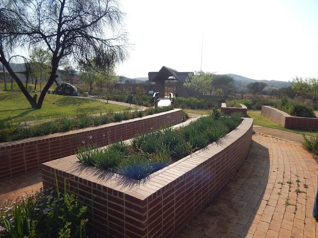
It was far more beautiful and well maintained than I had ever expected and its free. It has ample parking with good security. A great entrance and beautiful indigenous garden and manicured grass for family picnics and functions. Everything is well marked and good information boards. The ablution blocks are clean and well maintained.


The reserve is secured within a 680 ha oasis that will take your breath away. In fact it is actually the largest proclaimed nature reserve in the Johannesburg Metropolitan area and home to some big game like Eland, springbok, blesbok, red hartebeest, kudu, black wildebeest, mountain reedbuck and my favorite zebras! You will also spot the smaller game like the dassies and shy duikers.


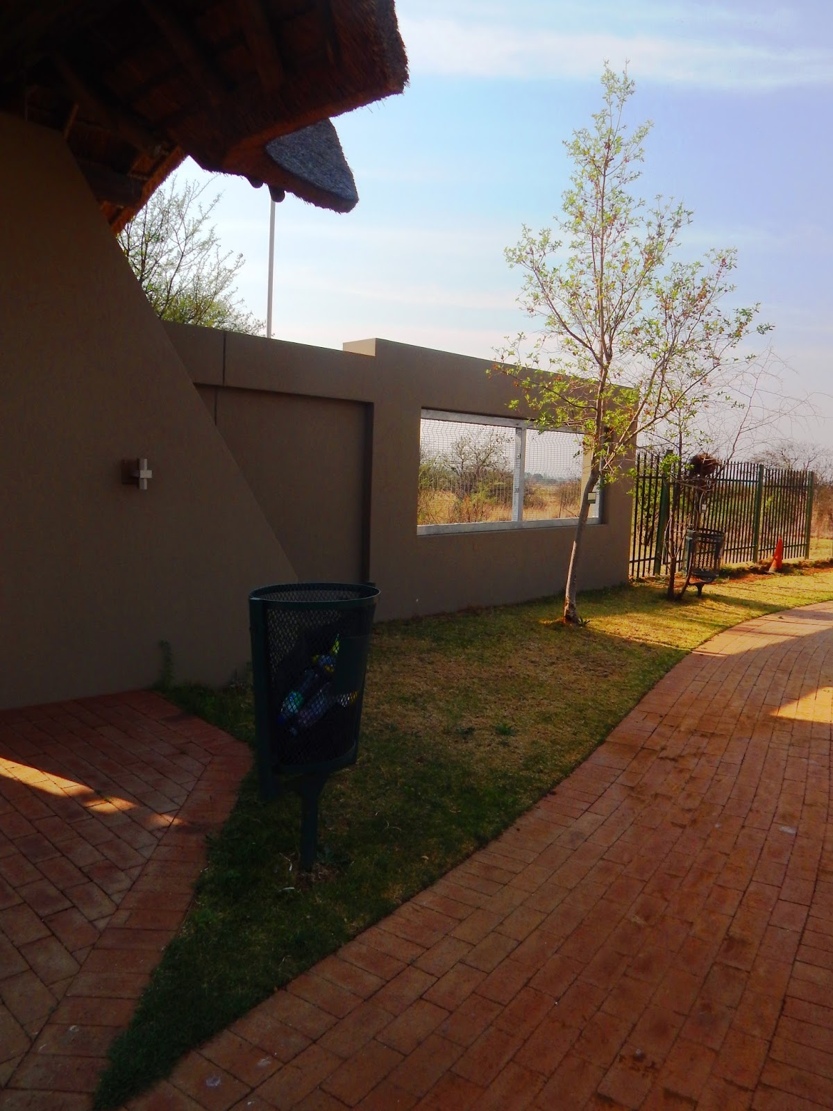

The reserve is fenced and safe. My sister and I tackled this alone and never felt unsafe once

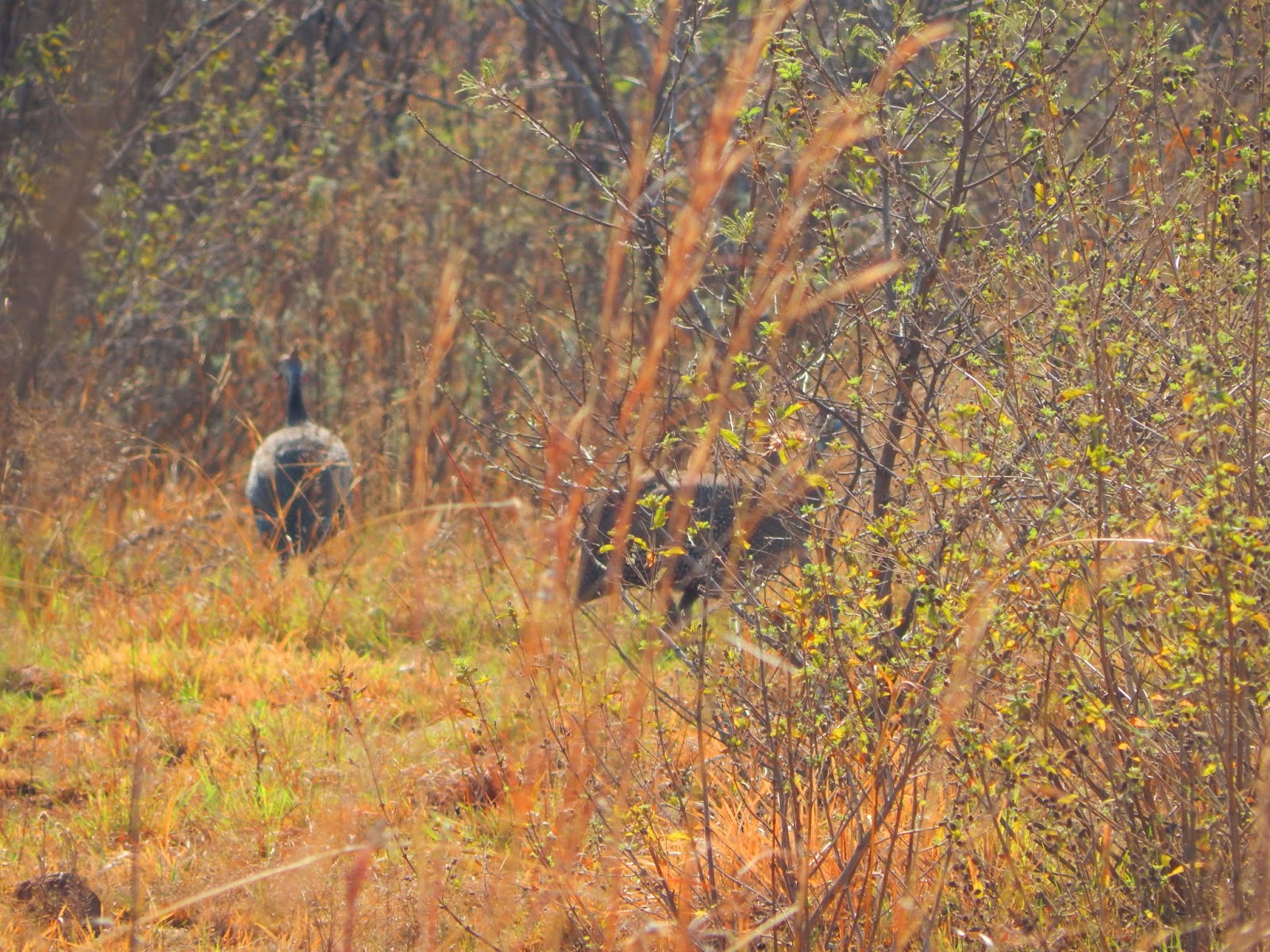
There is an abundance of beautiful botanical gems with many protected species, in fact some 650 indigenous plants and trees and a feast of geological, archaeological, historical and cultural interests can be found here. It also has a rich variety of birds, some 215 odd and I sadly ran out of batteries for my fancy Nikon Cool Pix camera and had to resort to using my cellphone - still great quality but just not the same for those really clear closeups. Which means I have an excuse to go back!!


This little weaver was having a ball catching its food.


and this was when my batteries went flat!
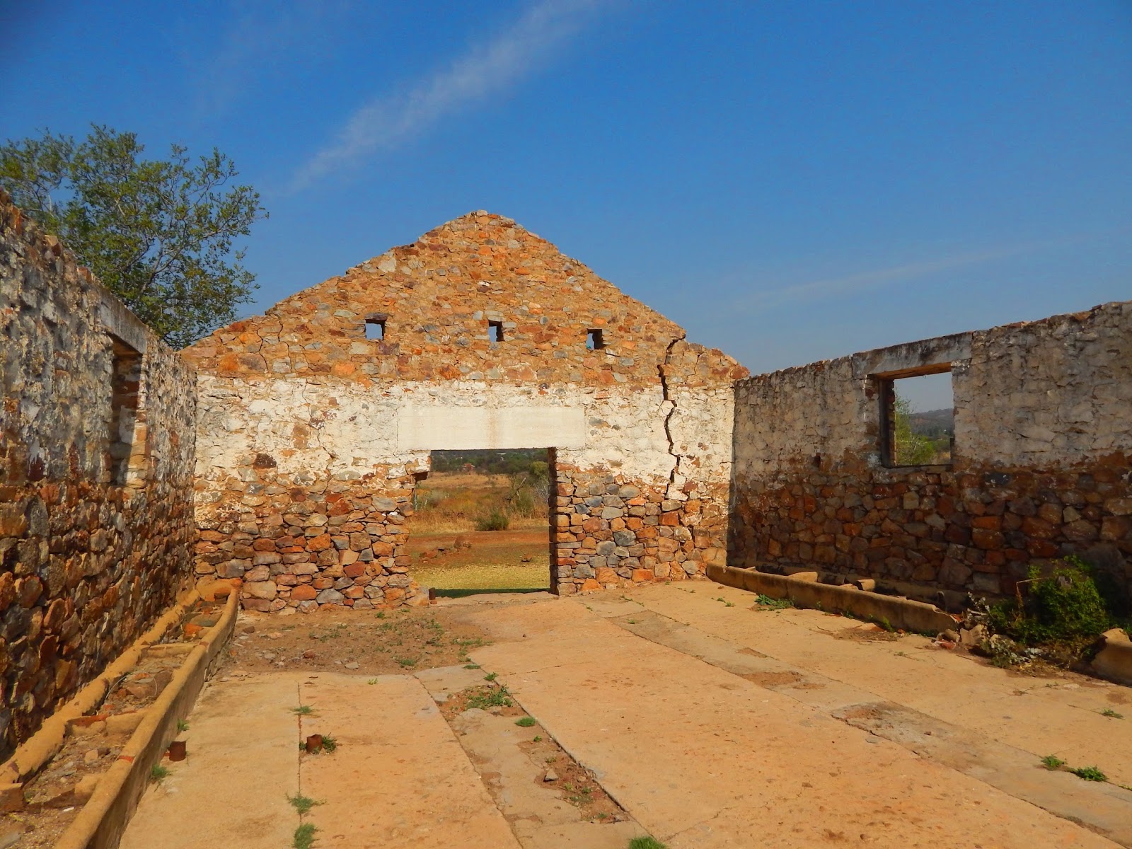
I was taken aback at this reserves rich archaeological and historical background and was drawn into the past and its landscape as it revealed some unexpected history.I found out that the reserve was first proclaimed in 1984 although the area has a rich history that can be traced back 250,000 years to the Stone Age.


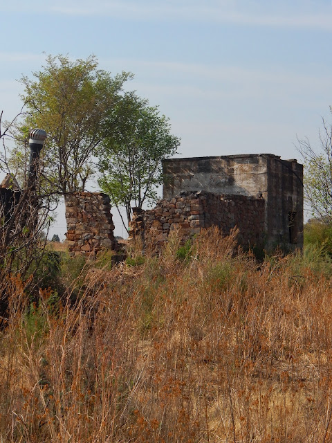
The Sotho speaking Tswana people lived and farmed here in this very area from 1400. Then some time after they had abandoned their villages in 1750, a “Voortrekker” farmer named Sarel Marais came to occupy the land in 1850, when he and his family bought the western section of the farm Rietvlei. I was really excited when we unexpectedly came across the walls of this house built in 1850 by one of the early Voortrekker pioneers, Sarel Marais as well as some sheds and other out buildings. And I grew up thinking he was a myth and his only claim to fame was a song named after him - I actually thought the song was named after a girl - shows how poor my Afrikaans is!!.


Some interesting History on both the Marais Family 1850s -1916 and the Quilliam Family 1916-1978


The reserve was bought by the Johannesburg City Council back in 1950. I took a lot of photos particularly for my daughter, She is a high-school History and Art teacher and university lecturer and is busy with her second degree in Archaeology. I will most definitely come back with her as my own personal tour guide!!It boasts the highest concentration of identified Iron Age sites on the Witwatersrand.


One of the rondavals we found not far from the main farm house


This had feeding troughs along the walls for live stock


These beautiful quartzite ridges found in Gauteng are characterised by some rather unique plant species that are found no where else and as such are considered one of our most important natural assets, found here in our northern provinces of South Africa. The Klipriviersberg Nature Reserve straddles a series of these ridges where is conserves the Bankenveld, a threatened veld type which is rich in beautiful flowering plants. As the largest nature reserve in Johannesburg, its size makes the re-introduction of Highveld species of game successful and viable creating an important eco tourist and educational hub.


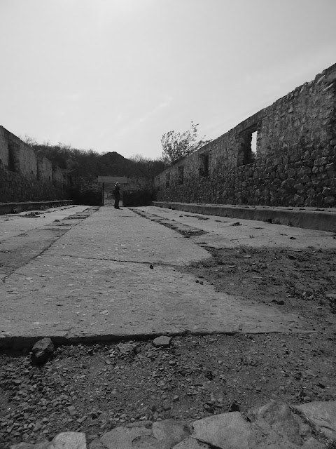
Many artifacts can be found in the reserve including ancient stone circles, the remains of early dwellings that are thought to date from about 1500. Pretty epic such incredible history right on our doorstep!!


There are also the remains of a BaTswana village and many unique iron age artifacts have been discovered within the reserve. This would suggest that humans hunted in the area tens of thousands of years ago. It is exciting to find out that 19 stone-walled settlements dating from about 1500AD have also been identified, together with an unbelievable 90 sites suggesting that there was once a rather large pastoral settlement in this area. Excavations also have revealed signs of agrarian production, the rearing of cattle and goats, as well as some hunting. The remains of a village provided evidence of an early Batswana community that once lived on the koppies in the area and evidence to indicate that they used the reserve as a hunting ground.


Further along we found the ruins of the Vierfontein dam at the Silent Pool which bears testimony of the importance that this perennial stream many believe played a part as an important water source for an early Johannesburg.
Just exploring the area and knowing some of the history you can see these small hills and plains are no stranger to war and a major part of the battle for Johannesburg in 1900 was fought in and around the Klipriviersberg hills and the remains of the concentration camp cemetery bears silent and sharp testimony to the deep cruelness of war and its consequences.


Sometime during the late 1970s, many of the local residents as well as many people who where familiar with the history and the area decided to petition the city council to set the area aside as a nature reserve. Thankfully the council agreed and the residents were requested to form an association which would work along side the city council to manage the reserve and as such this amazing place rich with history would be preserved for our children to enjoy. Due to this arrangement in October 1981, the Mondeor Koppies Association was established. The reserve was named Klipriviersberg Nature Reserve (KNRA) and was officially proclaimed in 1984. KNRA has over 1000 members and are always looking for more. Take a look at their site: Friends of Klipriviersberg Nature Reserve Association website: www,knra.co.za (this website seems to have a problem currently?)


So lets go back to the trails.Hiking is the main activity within the Reserve and it boasts a network of 20 km of marked trails. Most of the hiking trails are flat and scenic. They do however vary in distance and in degree of difficulty. A three hour hike along the flatter areas can be completed by most people with the steeper more hilly areas offering a bit of a test even for the fit. Its two longest trails are only from 5.8km to 9km.


You can walk solo on your own self guided hike or go on an organized walk. These take place every 2nd and 4th Sunday of the month. You can climb to the highest point at 1790 meters which is marked by an old trig beacon. The highest point provides a clear view of the Johannesburg (Jo’burg) (Jozi) skyline to the North.

These guided walks start at 08h00 during the warmer months (September to April) and 09h00 in the cooler months (May to August). Horse trails can also be arranged.


Guided mid-week walks are held on the first and third Wednesday of each month. These walks start at 9h00 at the entrance precinct in Peggy Vera Road, Kibler Park. If you are new to the reserve it is recommended that you join these guided walks. There is no charge.

Specialist walks
Specialist walks are held twice a year, in Autumn and Spring. Groups are guided by specialists in geology, archaeology, botany and history. they are about 3 hrs long.

Bird Walks
On the third Saturday morning of each month visitors can join a “bird walk” and discover some of the bird species that live in and visit the reserve.
Note: All walkers are led by experienced guides and offer an excellent opportunity for visitors to learn more of the history of the reserve and view the flora and fauna in their natural surroundings.

I have not taken part in any of these activities or guided walks yet, however its on my list to try each of them out and find out a bit more about this little gem on our doorstep.

Enviro Club
The Klipriviersberg Enviro Club offers young people from primary school level upwards the opportunity of physically contributing to the needs of the nature reserve. The group is involved in several important aspects of the reserve, ranging from clean-ups to alien plant removal. A very important aspect of their functions is also to have lots of fun. I know of some groups who have used this facility and had a lot of fun taking part.


I was told that from time to time there are additional activities that take place throughout the year, like snare hunts, alien vegetation removal and general clean-ups. Minor items of maintenance are also undertaken at the Precinct from time to time. I know my sons would like to join me in hunting for snares!!

Below is a great map of all the trails with the historical and archaeological sites clearly marked.
Region F, Zone 1
Address: Peggy Vera Road, Kibler Park
Telephone: 011 943 1312/2691
Reserve falls under JHB City Parks and Zoo: 011 712 6600
The Team Zodwa Project ™
Member: FGASA (Field Guides Association of Southern Africa)
Member: Vincent de Paul Victory Park (St Charles Catholic Church)
Member: Vincent de Paul Victory Park (St Charles Catholic Church)
Photo Credits: Kim Williams Copyright
_______________________________________
Warmest
.png)

Kim Williams | Adventurer | Founder The Team Zodwa Project & Adventure with a purpose | Finalist Johnny Walker/Sunday Times Nation’s Greatest Hero Award | #Reachoutbeahero & #Adventurewithapurpose & #Trek4Hunger Ambassador |Brand Ambassador Eatfresh SA| Public Speaker|Facilitator| Outstanding Founders list @MagnificHQ |Outstanding People List @GirlsRunThings | Blogger| Fizzical National Everyday Hero Winner
Mobile 083 962 6707
Twitter @777adventurekim
Facebook adventurekim.com777
Blog mountaingirl777.blogspot.com
Google google.com/.png)
“Life is an adventure…so live it. It’s your choice!”™


The Team Zodwa Project ™
Reach out...be a hero!™
_______________________________________


